
Highlights:
AVZ holds 75% of the Manono Project with rights to secure additional interests
Project covers 188km2 in southern Democratic Republic of Congo (DRC)
Hosts lithium pegmatites with a strike length of 13km+ centred on an historical Tin mining operation
Outstanding results received from AVZ’s initial drilling program at Manono in 2017, including 235m @ 1.66% Li2O, 202.8m @ 1.57% Li2O and 250.9m @ 1.48% Li2O.
Roche Dure Mineral Resource of 400 million tonnes grading 1.65% Li2O, 715ppm Sn, 34ppm Ta is world-class in scale and grade
The Manono Project is owned by AVZ (75%) and La Congolaise d’Exploitation Minière SA (25%) (Cominiere, a State-owned enterprise). AVZ is responsible for funding expenditure to completion of a feasibility study and a decision to mine.
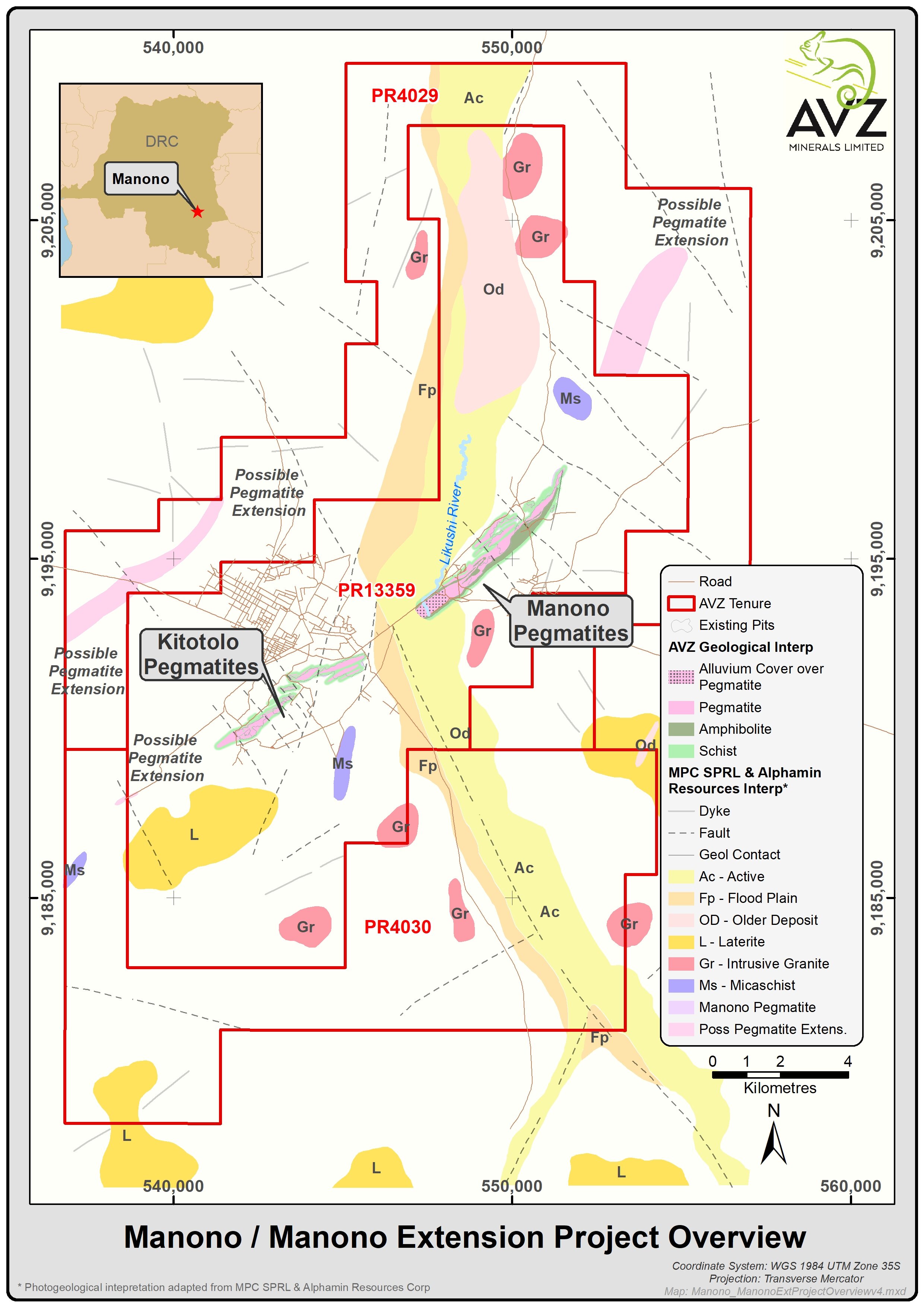
Tenure, location and infrastructure
The Manono Project comprises PR13359, which covers 188km2. The Manono Project is located 500km due north of Lubumbashi in the south of the Democratic Republic of Congo (DRC) in central Africa. The project area can be accessed from Lubumbashi by a 1.5 hour flight or by road.
Infrastructure in Manono and the surrounding areas is limited. Power is currently generated at the Manono township using diesel generators and a recently commissioned solar power system. Dathomir has agreed to facilitate the rehabilitation of Piana Mwanga hydroelectric power station and the road from Lubumbashi to Manono. The road is subject to a US$285m upgrade presently being completed.
There is an abundance of good water supply for both local consumption and any potential mining operation at Manono. Other consumables are bought locally and supplemented by goods brought in from Lubumbashi and Kalemie to the North.
Regional Geology
The Manono Project lies within the mid-Proterozoic Kibaran Belt, an intracratonic domain stretching for over 1,000km through Katanga and into southwest Uganda. The belt strikes predominantly SW-NE and is truncated by the N-S to NNW-SSE trending Western Rift system. The Kibaran is underlain in the east by Archaean rocks of the Tanzanian Craton and in the west and south by Lower Proterozoic metamorphic rocks.
The Kibaran belt comprises a sedimentary and volcanic sequence that has been folded, metamorphosed and intruded by at least three separate phases of granite. The latest granite phase (900 to 950MA) is assigned to the Katangan cycle and is associated with widespread vein and pegmatite mineralization containing tin, tungsten, tantalum, niobium, lithium and beryllium. Deposits of this type occur as clusters and are widespread throughout the Kibaran terrain. In the DRC, the Katanga Tin Belt stretches over 500km from near Kolwezi in the southwest to Kalemie in the northeast comprising numerous occurrences and deposits of which the Manono deposit is the largest known by far.
Historic activities
The historic Manono Mine was mined for its Tin content between 1919 and 1982, during which time a total of 100Mm3 (million cubic metres) of ore were processed to produce 185,000 tonnes of cassiterite concentrate, sourced mainly from eluvial and weathered pegmatite from which was recovered an average of 1,850gm of cassiterite concentrate per cubic metre (g/m3) or approximately 1,330g/m3 Tin.
With the exception of some exploration work carried out on the old mine dumps, aimed at determining cassiterite and spodumene grades, little prospecting has taken place since 1960.
Manono Mineralisation
The presence of lithium mineralisation in pegmatites at Manono has been confirmed to extend along strike for more than 13km.
Two large areas of pegmatite have been identified, with the northeast area, referred to as the Manono sector and the southwest area, referred to as the Kitotolo sector. Mapping within the two sectors has established that there are many pegmatites, representing separate intrusions, including six large pegmatites.
The large pegmatites all contain spodumene mineralisation. The majority of the smaller pegmatites also contain spodumene and in some cases other lithium minerals. The two largest pegmatites (known as the Carriere de l’Este Pegmatite and the Roche Dure Pegmatite) are each of similar size or larger than the famous Greenbushes Pegmatite in Western Australia.
In addition to geological mapping and trenching, AVZ completed an initial phase of due diligence drilling in 2017, comprising seven diamond drill holes for a total of 1,739m and testing four of the large pegmatites. In all cases, thick intervals of pegmatite were intersected and spodumene was present within all the pegmatites. The drill results included:
The Roche Dure Pegmatite has a proven length of at least 2,100m. Drill-holes MO17DD001 and MO17DD002 are centrally located within an 800m long interval in which the Roche Dure Pegmatite’s average true thickness is interpreted to be 200m and drilling has proven the pegmatite extends down-dip more than 250m and remains open. Secondary mineralisation in the form of tin and tantalum should not be discounted either.
The Mpete Pegmatite is estimated to have a strike length of 1km and the Tempete Pegmatite is estimated to have a strike length of 1.5km. Both pegmatites are potentially large sources of lithium mineralisation within the Kitotolo sector.
The Carriere de l’Este Pegmatite, with a mapped length of about 5,500m, is potentially the largest pegmatite in the Manono Project. Assay results from drill-hole MO17DD007 initially confirmed the mineralisation distribution and tenor evident from the spodumene present in the drill-core. Sampling commenced at 1.9m from which depth the pegmatite is unweathered. The thickness of intersected pegmatite and the geometric relationship between the location of the drill hole and mapped pegmatite boundaries suggests the thickness of the Carriere de l’Este pegmatite may be up to 280m true thickness at this location.
The initial drilling program has confirmed the immense size and potential of the Manono Lithium project.
Based on detailed prospect scale mapping, trenching and drill results, and given the size and mineralised nature of the pegmatites at Manono, AVZ generated an exploration target of between 1Bt to 1.2Bt of 1.25% to 1.5% Li2O for the entire Manono Project, including between 300 and 400Mt of 1.25% to 1.5% Li2O for the Roche Dure Pegmatite alone. The potential quantity and grade of the exploration target as stated, is conceptual in nature as there has been insufficient exploration to estimate a Mineral Resource and it is uncertain if further exploration will result in the estimation of a Mineral Resource.
The Roche Dure Mineral Resource now stands at 400 million tonnes at 1.65% Li2O, 715ppm and 34ppm Ta as reported in May 2019 and includes 269m @ 1.65 Li2O of Measured and Indicated Resources. Additionally the Roche Dure deposit has reported JORC compliant Tin and Tantalum resources of 275m @ 962ppm Sn and 38 ppn Ta for 264,55t of Sn metal and 10,450t of tantalum metal. At this size, Roche Dure stands as one of the largest and highest grade undeveloped hard-rock lithium deposits in the world.